Back in the day, cyclists keen to keep a record of their travels had to employ a map for directions and listen to the relentless click of a metal wheel clip nudging against a mechanical device for recording the miles travelled, but Garmin’s touchscreen Edge 800 cycling GPS unit cuts a far more modern dash.
Cycling in colour
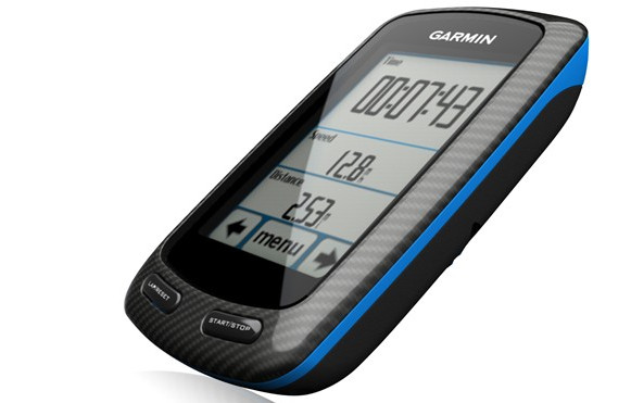
Their new touchscreen-based Edge 800 comes with a 2.6-inch colour display, and offers new mapping options like Garmin’s BaseCamp route planning and BirdsEye Satellite Imagery for keeping riders on track.
“Whether you’re on the road, in the mountains or around the city, Garmin’s touchscreen Edge 800 puts the most important information of your ride at your fingertips,” spake Dan Bartel, Garmin’s vice president of worldwide sales.
“Thanks to its simple mounting system, improved mapping and route-planning capabilities, and the GPS-based features that make wires and calibration obsolete, we can easily say that one Edge fits all.”
Calibrate ye not
The Edge 800 needs no fiddly calibration to set up, so riders can use it on different bikes, with the unit able to be positioned on the handlebars or stem via a low profile mount.Maps are loaded via microSD card.
Garmin say that their high-sensitivity GPS receiver with HotFix can snappily acquire and lock on to satellites, and the Edge 800 also displays temperature readings, changes time zones automatically with the battery lasting for up to 15 hours on one charge.
The Edge 800 should be available in October, with Garmin offering two configurations: a standalone version for $449.99 or a pricier $649.99 bundle that lobs in a wireless speed and cadence sensor, a City Navigator microSD card, and Garmin’s new premium heart-rate monitor strap.
Early review
Mustard keen cyclist DC Rainmaker has given the unit a thorough testing
and added a few hands-on video of the Edge in action.
In short, he loves it:
In summary, this device rocks. It’s everything that most cyclist have been asking for – even if they didn’t know they were asking for it. I love the new mapping capabilities as it bridges the gap from hard to decipher street maps, to crystal clear satellite imagery.
The ability to create custom maps is really really cool, and I’m looking forward to folks whipping up some relevant maps for cyclists and longer races. Plus – and perhaps most importantly – my fiancée has immediately decided she wants one…now.
Here’s the official press release:
Touchscreen Edge® 800 from Garmin® Blends Best of All Worlds: Streamlined Data, Route Planning and Color Mapping
OLATHE, Kan.–(BUSINESS WIRE)–Garmin International Inc., a unit of Garmin Ltd. (NASDAQ: GRMN), the global leader in satellite navigation, today announced the feature-packed touchscreen Edge 800 for cyclists who want accuracy and simplicity when tracking their statistics and location for racing and recreation. Edge 800 seamlessly combines the most popular aspects of the industry-leading Edge 500 and Edge 705 while adding an intuitive touchscreen interface. New mapping options such as Garmin’s BaseCamp route planning and BirdsEye™ Satellite Imagery make it perfect for training, touring and riding on the trail. Edge 800 will debut at Interbike (Booth 2631) and Eurobike (Booth A5-201), where it won the coveted Eurobike Award for electronic components.
“Whether you’re on the road, in the mountains or around the city, Garmin’s touchscreen Edge 800 puts the most important information of your ride at your fingertips,” said Dan Bartel, Garmin’s vice president of worldwide sales. “Thanks to its simple mounting system, improved mapping and route-planning capabilities, and the GPS-based features that make wires and calibration obsolete, we can easily say that one Edge fits all.”
Building on its popular predecessors, Edge 800 is smaller and sleeker than the Edge 705, yet features a larger 2.6″ display with a simple touchscreen interface. And while Edge 800 gets its streamlined design from the ultralight Edge 500, the color display and versatile mapping options make exploration more enjoyable and efficient than ever. The latest version of Garmin’s free BaseCamp software (www.garmin.com/basecamp) gives users an easy tool to survey the terrain and plan routes. BaseCamp lets users plan and preview routes – along with viewing elevation changes – and then send those routes to Edge 800, Edge 705 and Edge 605 as courses to follow.
In its third year as title sponsor of the Pro Tour cyclists of Team Garmin-Transitions, Garmin has worked closely with the sport’s top athletes in developing Edge products that can be appreciated by cyclists around the world using a cycling computer to get their fastest time – or for the first time.
“At Garmin-Transitions, we’re going to be on the cutting edge of technology, in everything we do,” said Team Garmin sprinting sensation Tyler Farrar. “Edge 800 can track all of our performance data, and it also keeps things interesting on training rides because we can use it anywhere in the world to plan and follow new routes – on and off road – and always find our way back to the start.”
Cyclists can view Team Garmin’s featured rides – or download, analyze and share rides of their own – at Garmin Connect™ (http://garminconnect.com), the free-to-join online community of more than 30 million activities from around the world. Garmin Connect displays metrics such as time, distance, speed, elevation and heart rate through charts and a variety of map representations, including street, satellite, topographic, and elevation maps. Garmin Connect users can search for activities in their area and try them by uploading the data to Edge 800, which will guide the way.
“I can come back and do even more on the computer when I download it,” said Team Garmin’s Christian Vande Velde of combining Garmin Connect with the Edge products he used in consecutive top-8 finishes at the Tour de France. “It takes all the guessing out of everything in my training.”
Using information directly from GPS satellites, Edge 800 accurately tracks speed, distance, time, GPS position, elevation, calories burned, climb and descent. For even more real-time data on display, Edge 800 syncs wirelessly through ANT+™ technology with compatible third-party power meters as well as Garmin heart rate monitors and speed/cadence sensors. For extra-precise climb and descent data, Edge 800 incorporates a barometric altimeter to pinpoint changes in elevation.
Because Edge 800 requires no calibration, it can be switched quickly between bikes thanks to a low-profile, quarter-turn mount that fits easily on the stem or handlebars with tight-gripping rubber rings. Boasting a high-sensitivity GPS receiver with HotFixTM that quickly acquires and maintains satellite reception, Edge 800 displays temperature readings, changes time zones automatically, lasts up to 15 hours on one charge and alerts riders if they’re moving but the timer has not been started.
As powerful as it is for performance cyclists and speed specialists, various mapping options make Edge 800 an ideal device for singletrack exploration, everyday errands and casual commuting.
On the trails, using a separate TOPO U.S. 24K DVD or microSD card brings you the highest level of topographic detail available, with maps comparable to 1:24,000 scale USGS maps, featuring terrain contours, topo elevations, summits, routable roads and trails, parks, coastlines, rivers, lakes and geographical points. In town, optional City Navigator mapping provides detailed street maps, millions of preloaded points of interest and onscreen turn-by-turn directions to your destination.
Subscribers to BirdsEye Satellite Imagery can quickly transfer high-resolution satellite images to Edge 800 and seamlessly integrate those images into the onscreen maps to get a true representation of the surroundings. And Garmin’s Custom Maps can bring the details, labels and landmarks of your existing paper or electronic map to Edge 800 in just a few simple steps.
Edge 800 is the latest breakthrough from Garmin, which has spent more than 20 years developing technologies and innovations to enhance users’ lives, making Garmin a household name in the automotive, aviation, marine, wireless, outdoor and fitness industries. For more about pricing and availability, as well as information about Garmin’s other products, go to www.garmin.com and www.garmin.blogs.com. For more about Team Garmin, visit www.garmin.com/teamgarmin.