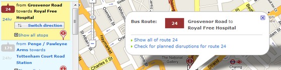
Transport for London have released their all-new interactive bus map, and we’re feeling the love.
Using the map is dead simple: just type in a postcode, station or landmark and the interactive map will show you all the buses that go past that place, with the option to view the entire bus route overlaid on a London street map.

You can also check for any planned disruptions on your route, with the information appearing in a separate browser window.
Individual bus route numbers can be typed in, with the route displayed on a map, and the main stops on the way listed in a side panel.
Clicking on a stop brings up the timetables (split into ‘day’ and ‘night’ tabs) and information on any related routes, with a text only version also available.
We like it very much. Way to go TFL!


Great idea, but needs some tweaking. Searches seem hit and miss (“Ealing Broadway station” leads you to somewhere in Southall), and many (of my local) bus routes seem to be absent.
this is terrible! where are the bus routes?!!!! you used to be able to see clearly on one map where you could go from any point now you have to search through a list. terrible. at least let keep the old maps on the TFL website
As at Jan 2014 This is no longer on-line
All you get is a list of route which pass through the postcode/town you entered, and clicking on these returns a linear list of the stops.
No explanation on the tfl site (yet another instance of tfl’s complete disregard for proper customer service)